Walking in Greece
Greece, the cradle of European civilisation, offers a lot to travellers and walkers. A sunny climate, rich culture, stunning landscapes, Mediterranean islands and mountains. For much of what Greece has to offer there is no better way to experience it than on foot.
In this introductory guide you can find out about the different regions of Greece, and what they have to offer. You’ll find info on popular areas for walking: Greece’s various mountains ranges, national parks and the Greek islands. We finish with a few words about the country’s climate and the best time of the year for walking in Greece.
We hope this information will prove useful when planning your walking holiday in Greece. For a wide variety of self-guided and guided walking holidays in Greece, all offered by local independent businesses, see our page walking holidays in Greece.
Geography of Greece
France is the largest country in Western Europe and has a wide range of landscapes. So much variety means there is something for everyone who wants to go walking in France.
Greece lies in southern Europe, in between Albania, Macedonia, Bulgaria and Turkey. With its many islands and indented coast, Greece has one of the longest coastlines in the world. Next to the many islands – there are over 1400 – Greece’s mainland consists of a large peninsula reaching out into the Mediterranean Sea.
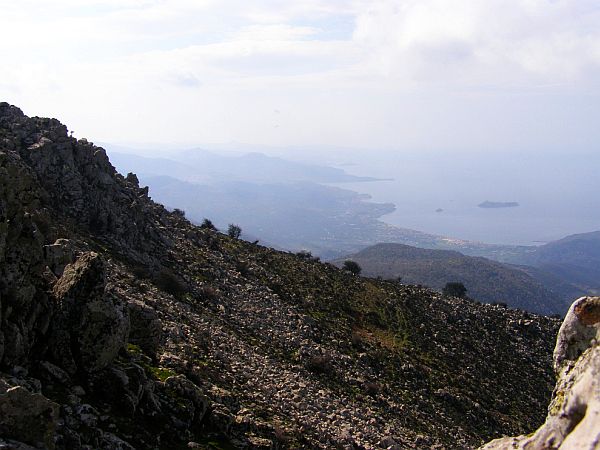
Greece is also one of the most mountainous countries in Europe, with over 80% of the country consisting of areas with significant relief. As a result the country offers some amazing opportunities for walking through varied and dramatic landscapes.
Walking in the mountains of Greece
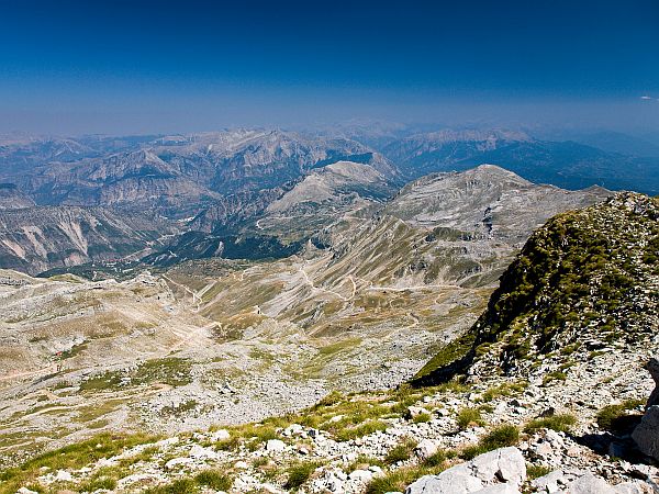
Greece has several mountain ranges that are all popular walking and hiking destinations. See the map below for the main mountain ranges. There are also significant mountains on Crete, on which you’ll find more in the section on the Greek islands.

Olympus Mountain range
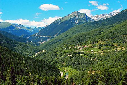
Olympus (also spelled Olympos) is probably Greece’s most well-known and popular mountain walking destination. It’s only 100 kilometres from Greece’s second largest city, Thessaloniki, and includes the famous Mount Olympus. At an impressive 2,917 metres (9,570 feet), Mount Olympus is the second largest mountain in the Balkan Range (only mount Musala in the Rila mountains in Bulgaria is higher).
The mythical mountain used to be best-known as the home of the 12 Gods of the ancient Greek world. But nowadays it’s the area’s natural beauty that enchants people. The Olympus mountain massif covers about 500 square kilometres, and the actual mountain range consists of 52 peaks. These range in height from 760 to 2917 metres with Mytikas being the highest peak. The mountain chain started to form 200 million years ago and was mostly shaped during and after the ice ages, when huge layers of rock where transported to the foothills.


Characteristic for the area are deep gorges, alpine meadows, rocky peaks and dense forests. Mount Olympus was Greece’s first National Park, already designated in 1938. There are many marked walking routes in the area, and several mountain refuges that offer accommodation and food to walkers and hikers. Climbing mount Olympus is not classified as a technical hike, it’s only the last section from Skala summit to Mytikas that requires rock scrambling.
It’s an interesting aside that many people think Mount Olympus was the original site of the Olympic games, but this is not the case. The site was in Olympia, a fertile valley in the Peloponnese peninsula, hundreds of miles away from Mount Olympus.
Taygetos mountains – Mani – Peloponnese
The name of the Taygetos mountain range is one of the oldest in Europe; it’s already mentioned in Homer’s Odyssey. These mountains were formed when the Eurasian plate collided with the African plates, at the same time the Alps were formed. The highest mountain in the range, the Profitis Elias, at 2,407 metres is a so-called ‘ultra prominent peak’. This means that the mountain is over 1,500 metres high and a very visible element in the landscape.


The bedrock of this 100 kilometre long mountain range consists of limestone with many creeks washing down from the mountain slopes. We think the area has been inhabited since about 1500 B.C. There are many ancient settlements in these mountains, including the citadel and monastery of Mystras and the mountains tower over the cities of Sparta and Kalamata.
The Taygetos mountains are a popular walking holiday destination. The slopes of the mountains are heavily forested, mainly with Greek fir and black pine, and the views from the summits are wide and impressive. Part of the European E4 long distance walking route runs through the Taygetos mountains, but in many places the route is not very clearly waymarked.
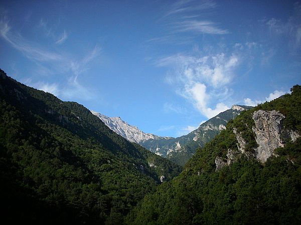
The Pindus mountains
Because the Pindus mountain range runs north – south, dividing the country, it’s also known as the spine of Greece. This 160 km long mountain chain runs all the way from the Greek-Albanian border to the north of the Peloponnese peninsula. There are some high peaks here, with Mt Smolikas being the highest at 2,637 metres. The geography of the area is varied, ranging from hills to steep mountains and deep canyons.


There are many extensive woodlands in the region. You’ll find conifer forests with Greek Fir and Juniper at the highest elevations, and broad-leaved forests in the lower areas and the valleys and canyons down below. The Pindus mountains are dotted with villages. There are also two national parks, Vikos-Aoos National Park and Pindus National Park.
Close to the Pindus mountain range you’ll find the Meteora world heritage listed complex. It consists of six monasteries built on natural sandstone rock pillars. Meteora in Greek means “suspended in the air” or “in the heavens above” – a very fitting name for this spectacular cultural heritage. Until the 17th century, the main way for people and goods to reach the monasteries was by means of baskets and rope!

The Meteora complex is a stunning place in Greece.
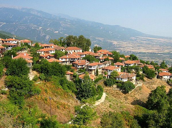
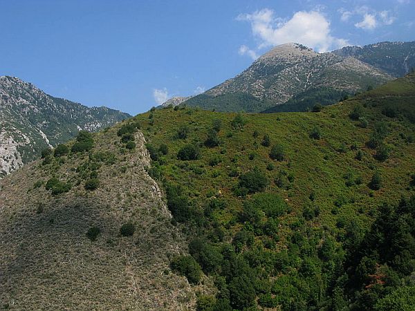
The Pelion mountains
The Pelion mountains are a hook-shaped peninsula in central Greece near the west coast of the Aegean Sea. These are lush green mountains, with abundant water features such as springs and streams. The woodlands consist of a mix of oak, maple, beech and chestnut, with planes abundant near water. The area is known for its thriving orchards, and there are many villages with traditional architecture in the area.

The Pelion peninsula in Greece is a lush, water-rich place popular with walkers and hikers.
The Pelion mountains are very popular for walking holidays; there are many paths and trails leading to coves and beaches, lush forest and spring, and picturesque villages. From the mountain tops there are wide views across central Greece and over the Sporades islands. The Pelion is generally cooler in summer than other regions in Greece, especially the higher mountain villages, which is ideal for walking. The area receives a decent amount of snow and skiing is possible in winter.


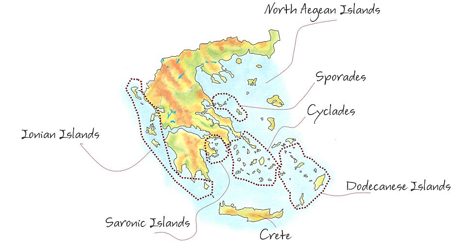
The Greek islands
There are more than 1400 islands around Greece, and people live on 227 of them. The Greek islands are normally divided in two main island groups, the Ionian islands in the west, and the Aegean islands in the south and east.
The Ionian islands of Greece
This islands group to the west of Greece consists of 6 bigger islands and quite a few smaller ones. One of the significant six, Kythira (known as Cerigo in English) is located to the south of the tip of the Peloponnese peninsula. The others all lie along the west coast of Greece and are Kerkyra (also known as Corfu), Paxi (also known as Paxos), Lefkada (also known as Lefkas), Ithaki, (also known as Ithaca), Kefalonia, Zakynthos (also known as Zakos). The Ionian islands have a mild Mediterranean climate, and most of them also have fairly mountainous sections and long sandy beaches.

View on a bay on Corfu, one of the Ionian islands.
The Aegean Islands
The Aegean Islands are all found to the east and south of mainland Greece, in the Aegean Sea. The ancient name for the Aegean Sea was Archipelago, and this name was later also applied to the islands. Nowadays, archipelago is used to refer to any island group. Even though Turkey also borders the Aegean Sea, there are only two Turkish islands, Imbros and Tanados. All the rest are Greek islands. The islands are further divided into several islands groups, some of which are discussed below.

Map showing the Greek island groups in the Aegean Sea.
The North Aegean islands
The North Aegean islands do not form a distinctive physical group, but are often grouped together for administrative and touristic purposes. They include some fairly large, and most of them lie close to the Turkish Coast.
Samos for example is about 43 kilometres long and 13 kilometres wide. The island is mountainous with the landscape dominated by two large mountains, Ampelos and Kerkis but there are also fertile plains. The climate is typically Mediterranean, and the region is mainly agricultural, producing, wine, honey, olives and citrus fruits.
.")
An ancient bridge on the island of Lesbos in Greece.
Lesbos is Greece’s third largest island with 320 kilometres of coastline. The island is also known as Lesvos and has a volcanic origin and evidence of this can still be in several hot springs and the two gulfs in the island. It’s very sunny with a mild Mediterranean climate. Lesbos is mountainous with two large peaks that are just under 1 kilometre dominating the central and north parts of the island. It’s very green with forests of pines, chestnuts and oaks and scrub and grass habitats. Lesbos is exceptionally rich in flora and also a birdwatchers paradise.

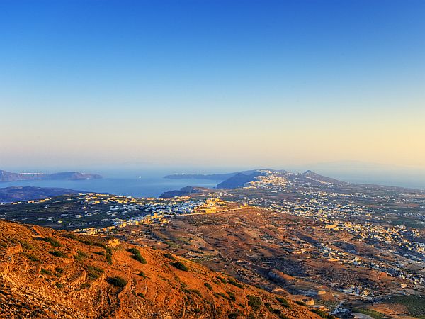
The Cyclades
The Cyclades consist of a large group of 220 islands, but many of the smaller islands are not inhabited. Some of the major islands include Tinos, Naxos, Mykonos, Paros and Santorini. The islands are actually the peaks of submerged mountains, apart from two of the islands, Milos and Santorini, that are volcanic in origin. The climate is dry and mild on most islands, staying very mild even in winter. This makes it possible for products like wine, olive oil, fruit and wheat to grow. There are many interesting cultural sights on the islands, and the Cyclades are now a popular holiday destination.


Crete
Crete is the largest of the Greek islands, and also the fifth largest island in the Mediterranean. It’s elongated in shape and very mountainous, with a high mountain range running from east to west. These mountains actually consist of several separate mountain ranges which include the white mountains – or Lefka Ori, so called because their white-coloured limestone summits and snow in winter give them white peaks all year round. Other mountain ranges are the Idi range, the Dikti, Kedros and Thripti mountains. The Psiloritis mountains are part of the Psiloritus National Park. The highest summits on Crete reach almost 2500 metres.

Autumn landscape on Crete.

View on Psiloritis mountains in Psiloritus National Park on Crete.
On Crete you’ll also find several impressive gorges, including the famous Samaria gorge. There are waterfalls, rivers, fertile valleys and plains and freshwater lakes. Crete’s coastline is surrounded by small islands and rocks. The island is the meeting place of two climates; the Mediterranean climate rules in the north part while the south part experiences a north African climate with significantly more sunny days and warmer temperatures. In this part date palms produce fruit and the swallows don’t migrate but stay on the island all year long.

The Samaria gorge is one of the major tourist attractions of the island and has been made a national park. Crete was the centre of the Minoan civilisation, one of the first in Europe. There are many interesting cultural and archaeological sights on the island. Flora and fauna are also very varied with 200 species of orchids and marine animals such as sea turtles and dolphins, and even whales occurring in a deep area of the Mediterranean just south of Crete, known as the Greek Abyss. You can admire the sea life in one of the two aquariums in Greece. With such a varied geography and cultural and natural heritage, Crete is a great destination for a walking holiday.


Sporades islands
The Sporades are a group of islands just off the east coast in Greece. There are about 11 islands but only 4 are inhabited; Skyros, Skopelos, Skiathos and Alonnisos. The islands have a varied relief and green vegetation, and they are still relatively quiet and unspoilt with whitewashed houses and traditional life.
The Dodecanese islands
The Dodecanese islands lie in the far south-east corner of the Aegean sea, along the coast of Turkey. They consist of a group of 12 larger plus 150 smaller islands, of which 26 are inhabited. The most well-known are Patmos, Rhodes and Kos. The islands have a rich cultural heritage, and even the smallest islands have many sights such as Byzantine churches and medieval castles. Rhodes, the biggest of the islands has a mountainous interior, sparsely inhabited and vegetated with forests of pine and cypress. The city of Rhodes and the coast is where most people live, and there are many beach resorts.


The Saronic islands
The Saronic islands lie very close to mainland Greece and Athens, and many Greek people have second homes here. Salamis, for example, has about 31,000 permanent residents, but during the summer season the number of people on the island rises to 300,000. The islands are rocky and mountainous, but many also have good beaches. Some of the islands are volcanic in origin, such as Aegina. The Saronic islands are rich in archaeological and cultural remains.
Greece’s Climate
Greece generally has a Mediterranean climate, but the large variation in landforms, height and proximity to the sea account for many local differences. The Pindus mountain range, that divides the country roughly in two, acts as a barrier. The area west of the Pindus range is generally wetter than that to the east, that experiences the rain shadow effect. Most coastal areas have a warm Mediterranean climate, as do most of the Greek islands. However, Greece’s largest and most southerly island, Crete, is hotter and has a more African climate in the south part.

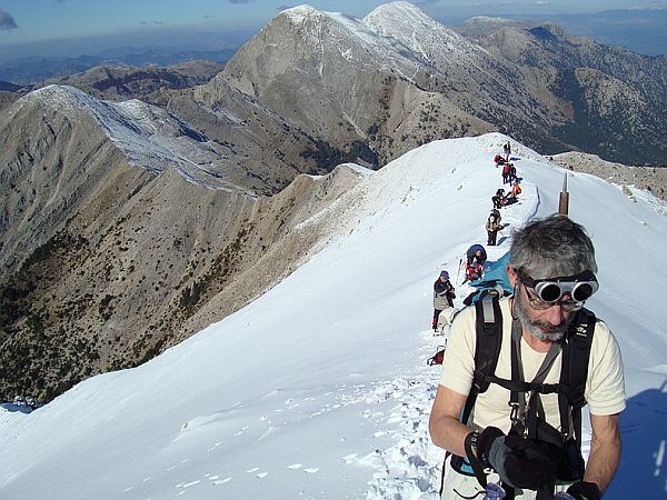
A walker climbing the peak of Profitis Ilias in the Taygetos mountains in Greece. Sunny dry weather is the norm here in summer.
Greece’s Mediterranean climate means warm dry summers with any rain often occurring only as isolated thunderstorms. Heat-waves do occur but not so often especially where the Etesian winds blow. These seasonal winds blow roughly from May to October and mostly in July and August. They help to keep temperatures more pleasant. Winters are much wetter. The higher mountainous parts of Greece, such as the Pindus mountains, and the Rhodopes near the border with Bulgaria and Macedonia experience an alpine climate.
National parks in Greece
There are 10 official national parks in Greece. Here you can read about those most interesting for walking and hiking.
Samaria Gorge
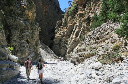
Samaria Gorge National Park lies in the west part of Crete, in the White Mountains or Lefka Ori. The gorge formed through erosion caused by a small river. The most spectacular part of the gorge is the stretch known as the Iron Gates, where the gorge is only four meters wide and soars up to a height of 1,100 metres. One of the iconic species of the park is the rare Cretan goat or Kri-kri, that inhabits the steep rocky slopes. There is a popular hike through the gorge, of about 16 km length, which takes about 4-6 hours to complete and can be strenuous in hot summer weather. The walk is normally done from the Omalos plateau to Agia Roumeli on the Libyan Sea, from where you can sail to a nearby town and take a coach.

Walking through the Samaria Gorge on Crete.
Vikos – Aoös National Park
Vikos – Aoös National Park is found in the north-west part of Greece, in the Pindus mountains. There are two main gorges in the area, the Vikos and Aoös gorges, from which the park takes its name. The park covers 12,600 hectares and consists of mountainous terrain with rivers, lakes, caves, deep canyons, and dense coniferous and broad-leaved forest. The core of the park consists of the Vikos gorge, a 12 km long gorge and reaches a depth of 1000 metres. The Aoös gorge is 10 km long.

The Vikos gorge in Vikos – Aoös National Park in Greece.
The park also comprises the Tymfi mountains that reach heights of almost 2,500 metres. Here you’ll find alpine meadows and lakes with rare amphibians. There are also many caves in the area.
Four settlements are found within the borders of the park. These are interesting authentic villages with a specific architecture and layout. The area has many beautiful and ancient stone bridges , and the 15th century Monastery of Saint Paraskevi offers beautiful panoramas over the Vikos gorge and the surrounding landscape.
Needless to say this interesting area is a popular destination for walking and hiking. One of the most popular walks is the walk through the Vikos Gorge itself, but there are also interesting walks to the peaks of the Tymfi mountains, and to several viewpoints that are only accessible on foot, including the monastery. The area has a Mediterranean climate with hot dry summers and wet winters.
Pindus National Park
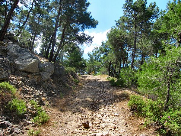
Pindus National Park also lies in the Pindus mountain range, near the town of Metsovo. The area consists of dense forests of European black pine and common beech, rocky ridges, peaks over 2,000 metres, rapid streams and mountain lakes. The park is one of the least visited and least known in Europe, a situation not helped by the fact that there is no signposting to the area from main roads. There are good opportunities for walking on the many dirt roads in the area, and if you’re planning on going there, the way to get there is from the north through the village Perivoli.
Mount Olympus National Park
For a description of Mount Olympus park, see above
Long-distance walking paths in Greece
The south-east part of the E4 long distance walking path through Europe also runs through Greece. Part of the route in this part of Europe is not clearly defined yet, with waymarking missing or no route set-up at all, like in Romania and parts of Bulgaria. The route is known in Greece, but in many places, especially in key places, it is not waymarked. So if you’re planning to hike the E4 in Greece, expect delays caused by taking a wrong route. Also diversions may be necessary because the original route is blocked, or dangerously eroded, and streams and rivers may be impassable because of snow melt, or rain, especially in May. Some of the route is along roads. However, for anyone with a sense of adventure this will be an interesting challenge. No doubt you will enjoy the warmth of the Greek people and the sun.
If you intend to walk this route, you are well advised to carry out some good research. A good starting point for information is the Wikipedia page on the E4 walking route in Greece.

Sign along the E4 long distance path in Greece.
Part of the E6 long distance path also runs through Greece, starting in Igoumenitsa, travelling all the way to Turkey close to the Macedonian and Bulgarian border to Alexandropouli in the east. More information can be found on the website of the European Ramblers Association section on the E6.
The best time for walking in Greece
With a varied topography, including mountains well over 1,500 metres, local climates differ across Greece. The general climate however is Mediterranean, meaning hot, dry summers. Hot summer weather is not always ideal for walking, so in truly Mediterranean areas, April and May or the autumn can be the very best time; the weather is often sunny and pleasant then. In the spring the whole countryside is green and in bloom, while you can enjoy the turning colours and golden light in the autumn. In the higher mountains, snow and colder conditions can linger longer, so April and even May might be too early there. But in summer these areas are cooler, and spring is also later there.

Spring is a beautiful time for a walking holiday in Greece.
Also winter, from December to March can be a good time to come for a walking holiday to warmer areas, such as some of the Greek islands. Weather is cooler, and it can be rainy or even cold, but there is also a good chance of very pleasant weather and this time of the year is ideal for sightseeing and walking, without the crowds.
For any area in Greece, it’s always best to consult with a local about your walking plans and the best time of the year for those. All the small businesses that offer walking holidays in Greece on this website know the area they’re in like the back of their hand and can give you the very best advice there is!


Greece
Capital: Athens
Area: 50,944 sq. miles, about half the size of the UK
Population: 10.8 million
Currency: Euro
Walking in Greece
With its long stretches of coast and many beaches, for many travellers Greece is a Summer destination. However, Greece also offers wonderful opportunities for walking and hiking. And because the Greek landscape is so varied, there is something for almost everyone. In fact, some would argue that some of the world's best walks are in Greece.
Greece is a large place and walking there you'll find lots of beautiful scenery, historic sights, and picturesque villages, all in a traditional setting. It's good to research the area you're planning your walking holiday, because there are big local differences. Some areas are rougher and more barren, especially some of the Greek islands, while other places, mainly on mainland Greece, are more forested.
Walking and hiking is quite popular in Greece. And that's part of the reason why you'll find many excellent trails here. Most of these are maintained by local walking groups or regional mountaineering clubs.
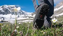
Greek nature is generally gorgeous, and there are many National Parks. In Springtime the amount and variety of wildflowers is stunning. April and May are the best months for hiking, with flowers in full bloom. March is also good, but could be a little early because the weather is still less stable then.
The Greek Autumn is also particularly nice for hiking with lots of golden light. From late September until early November you can have excellent, calm walking weather with comfortable temperatures and without the crowds. Summer is generally too hot for hiking in Greece, apart from maybe at higher altitudes where you can still find snow well into May.
Also, two of the European long distance paths go through Greece. The E4 enters Greece from Bulgaria in the North, and the E6 has a second section that starts in Western Greece.
Also See
Walking Holidays in Greece
Walking Holidays with both Guided & Self-guided Walks